
HLFY-BD-M200 GNSS receiver is the latest developed multi-mode multi-frequency high-precision receiver that supports the full frequency of the whole system by Hwa Create. It supports GPS L1/L2/L5, BDS B1I/B2I/B3I/B1C/B2A, GLONASS G1/G2, Galileo E1/E5a/E5b. It has the function of static calculation and carrier phase RTK, focuses on optimizing the sensitivity and RTK performance, and provides high-quality observation data and configurable update rate.
The HLFY-BD-M200 GNSS receiver has rich external interfaces, and has the functions of high-precision position information acquisition, large-capacity storage, remote control, data solution, wireless transmission, real-time display, power failure and endurance.
Environmental adaptability
lProtection grade: IP67
lWorking temperature: -40 ℃~85 ℃ (excluding battery)
lStorage temperature: -50 ℃~85 ℃
lHumidity: 10%~95% (non condensing)
lVibration: compliance with GB/T2423.10-2008
lDrop: compliance with GB/T6587-2012
lCollision: compliance with GB/T2423.6-1995
lSalt spray test: compliance with GB/T2423.17-2008
lAging resistance: meet the standards of GB/T3512-2014, GB/T2423.24-2013, GB/T16422.2-2014 and GB/T16422.3-2014
Network protocol
Support HTTP, TCP, FTP, and NTRIP protocols, including TCP Server, TCP Client, Ntrip Caster, Ntrip Server, and NtripClient; Compatible with Ntrip 1.0 and 2.0 protocols.
Electromagnetic compatibility
lRadio frequency electromagnetic field immunity meets GB/T17626.3-2006 standard
lElectrostatic discharge immunity meets GB/T17626.2-2006 standard
lPulse magnetic field immunity meets GB/T17626.9-2011 standard
lPower frequency magnetic field immunity meets GB/T17626.8-2006 standard
lSurge immunity meets GB/T17626.5-2008 standard
lElectrical fast transient pulse group immunity meets GB/T17626.4-2008 standard
Positioning indicators
Signal and frequency | BDS: B11, B21, B31, B1C, B2A GPS: L1, L2, L5 GLONASS: G1, G2 Galileo: E1, E5a, E5b |
Observation parameters | Carrier to noise ratio, pseudo-range code, full-cycle carrier phase of each frequency, Doppler frequency shift, navigation message |
Static measurement accuracy | Horizontal: ± 2.5mm+1ppm (RMS) Vertical: ± 5mm+1ppm (RMS) |
Real-time dynamic measurement accuracy | Horizontal: ± 8mm+1ppm (RMS) Vertical: ± 15mm+1ppm (RMS) |
Observation accuracy | Pseudo range accuracy: ≤ 250px Carrier phase accuracy: ≤ 25px |
Single point positioning accuracy | Plane<3.0m; Altitude<5.0m |
Receiver internal noise level | ≤ 1mm |
Initialization time | Cold start ≤ 50s, RTK initialization ≤ 10s |
Initialize Confidence | > 99.9% |
Data update rate | 1Hz, 2Hz, 5Hz, 10Hz, 20Hz (configurable) |
Time accuracy | ≤ 20ns(1σ) |
External interface
Ethernet interface | Quantity: 1; Interface type: RJ45; Transmission rate: 10/100Mbps |
USB | Quantity: 1; Interface standard: USB2.0 Support to copy original data from the receiver |
PPS output | Quantity: 1; Interface type: SMA |
Antenna | Quantity: 1; Interface type: TNC |
Wireless data | Compatible with 802.11a/b/g/n wireless network (supporting 5G and 2.4G bands) Support WiFi hotspot, Bluetooth 4.0 (supporting BLE), 4G all-network connection |
Power interface | Quantity: 1; Interface type: LEMO |
Data format and storage
Data output format | Real-time output via COM, network port or Bluetooth Differential message: CMR, RTCM2.3, RTCM3.0, RTCM 3.1, RTCM3.3 Observation data: RINEX, raw binary Positioning data / status information: NMEA-0183 V2.0/2.3 |
Data storage | Storage space 64GB Support different sampling intervals and different length of raw data storage Storage data format: support RINEX, compress RINEX, customize Support automatic storage and cyclic storage; Support USB drive mode export and FTP mode (client/server) export |
Display and control
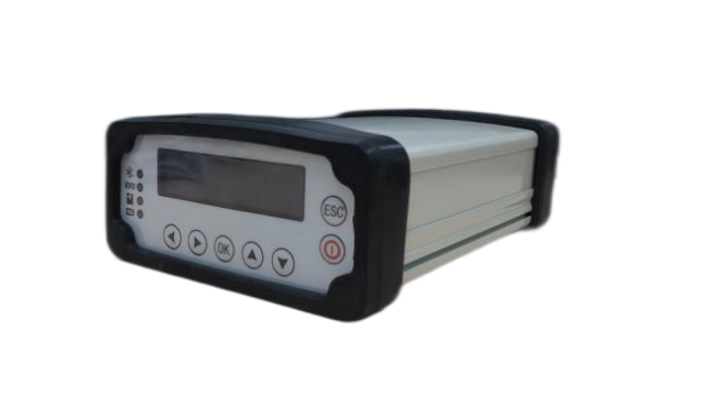
Status indication | OLED display; Display version information, tracking satellite information, positioning information, storage status, power status, network connection status, and general fault status |
Control | Parameters of COM, Bluetooth and network can be set and reset The receiver can be accessed remotely through the WEB for parameter configuration, restart, reset, power-on and self-start |
Equipment upgrade | Support firmware version upgrade via USB interface Support firmware version upgrade remotely via WEB |
Power supply and size
Input voltage | 9~36VDC |
Overall power consumption | 4.8W (in 4G sleep state) |
Power supply safety | Over-voltage and under-voltage protection; Accidental pole reverse protection; Reverse connection protection; Lightning protection |
Battery | Built-in 17600MAH lithium battery; Seamless switching between external power supply and internal power supply |
Overcharge and over-discharge protection | Work normally for more than 24 hours when the temperature is between -25 ℃ and+65 ℃ |
Appearance dimension | 220mm x140mm x70mm |
Weight | 1.9kg, the whole machine can be externally hung and fixed |
Application area
It can be used as CORS reference station, vehicle-mounted mobile base station, RTK base station, etc., and is widely used in geological disaster monitoring, national power grid monitoring, railway and water transport industry CORS network, GNSS ground-based CORS network, portable reference station, etc